Travel writer Şerif Yenen, this time as a historian, takes us through the history of Antalya and its surroundings.
HISTORICAL SIGHTS OF THE REGION ANTALYA (ATTALEIA)
Located in the region called Pamphylia, the port city of Antalya was founded by Attalus II, King of Pergamum in the 2nd Century BC, and nam-ed after him. Antalya remained a small city until its discovery by the tourism industry in the 80’s. This develop-ment in turn brought the city into the lime-light and since then it has been attracting migrant Turks and for-eigners alike who look for modern facilities within easy reach of nature and a pleasant climate throughout the year-the very things Antalya is naturally endowed with.
One of Antalya’s most popular area is the old port called Kaleiçi- meaning located within the castle vvalls. it has become a center point of attraction and the recent renovation of the old houses, and the small yacht harbor won Antalya an international award for excellence in architecture and preservation. Today, most of the houses have been turn-ed into small hotels and pensions. Antalya
Strange as it may seem, the city of Antalya does not have many historical sights when compared to the richness of the surrounding region. An important highlight of the city is the Archaeological Museum, which is considered to be one of the top five museums in the country.
THE TURQUOISE COAST
The Mediterranean Sea (Akdeniz) is the world’s largest inland sea and divides the continents of Europe and Africa. The origin of the name are the Latin words medius (middle) and terra (earth or land). This combination suggests that the peoples of ancient times believed the Mediterranean to be at the center of the world. The Taurus Moun-tains (Toroslar) stretch for about 485 km along the southern rim of the Anatolian Plateau. From Egridir Lake in the west, to the Seyhan River in the east, the Taurus range runs paral-lel to the waters of the Mediterranean. The west-ern Mediterranean coast, also known as the Turquoise Coast, is dom-inated by the Beydaglar range of the Taurus Mountains, where winding roads cling to the mountainside and climb high above sea level. Driving along the Turquoise Coast, one wonders if the name of the semiprecious stone was not derived from the color of the sea. Antalya
PHASELIS
Until the city of Attaleia was founded in the 2nd Century BC, Phaselis was considered to be the most prominent port city to the west of the Gulf of Antalya. Today, only surface excavation of the ancient city has been completed. Ancient ruins, and a forest surrounded by the sea on three sides ali combine to make this national park one of the most beautiful sites of the region, and well worth a visit.
According to the legend, Phaselis, was founded by colonists from Rhodes in 690 BC. Because the land was not suitable for agriculture, Phaselitans excelled as great traders. The stories suggest that they bought the land in exchange for dried fish, which is believed to have led to the emergence of the proverb “Phaselitan sacrifice,” which even today is used to refer to cheap offerings.
The three harbors of Phaselis, the north, the city and the south, are arranged around a 400-meter-long peninsula on which most of the city is situated. These harbors served the city’s trade activities, particularly the export of local timber, rose and lily oil. The North Harbor was the key point in terms of defense.
The largest is the South Harbor which is protected by a long break-water most of which is underwater today. The main street is between the middle harbor and the monu-mental gate near the south harbor. On both sides of the 22-meter-wide main street are important Roman and Byzantine public buildings, a batli complex, agora and other municipal buildings typical of the ancient cities. The Monumental Gate, built of gray-white marble blocks, was one of the buildings erected in honor ot Hadrian’s visit and bears a dedication to him. The Roman Theater which probably replaced an earlier Hellenistic theater, lies to the east of the main street on the hillside and dates from the same period. Antalya
MYRA
The ancient city of Myra, located a few kilometers north of D emre was one of the earliest Lycian cities. Myra has been renowned throughout centuries as the city where St. Nicholas lived in the 4th Century AD.
Saint Nicholas (c.300-350 AD) was born in Patara and became the bishop of the Christian church of Myra. His reputation for generosity and compassion is exemplified in many legends. One legend has it that he saved a poor man from prostituting his three daughters; on three separate occasions the bishop is said to have tossed a bag of gold through the chimney-the dowry he needed for each daughter to marry honorably. The stories provide the foundation for the custom stili practiced in many countries of gift giving to celebrate the Saint’s day, December 6th.
The inscriptions on coins found locally suggest that Myra’s origin must date from around the 5C BC. Myra was one of the most important cities of that period. During the Hellenistic period it was one of the six cities in the Lycian League that had three votes, the maximum quota given to any city for the federation meetings. Today Myra’s ruins consist mainly of a theater, tombs and the remains of an acropolis on the hilltop. The rest of the city has not yet been excavated and may hold many unexpected secrets. The Roman Theater is well built and full of features of interest. Backing the diazoma is the figüre of Tyche, the Goddess of Fortune, with an inscrip-tion reading “Victory and good fortune to the city beneath.” The 4C BC rock-cut Tombs, are some of the best existing examples of the Lycian style. The temple facades with beautifully carved reliefs repre-senting the dead and their families and the tombs, are among the most fascinating ancient remains in Anatolia.
St. Nicholas was buried in a tomb outside the city of Myra over which a the 6th Century it was replaced by a large church. This church is located in the town of Demre. The church was damaged by Arab raids and later repaired and surrounded by walls built by Constantine IX and the Empress Zoe in thellth Century. At the end of that Century, Italians from Bari broke open his sarcophagus and stole the bones of St. Nicholas. A famous church for pilgrims was built in Bari over the remains of the saint. The Italians apparently did not get the full skeleton, several relics of Saint Nicholas, such as the fragments of his jawbone and skull, are stili kept in the Antalya Archeological Museum.
KEKOVA
Kekova is a name given to the most scenic and extensive Lycian area along the Turquoise Coast. it consists of the Kekova Island, Kale (Castle) village and Uçagiz (the three mouths) village. Although you can reach the area by land, it is easier and more pleasant to go there via the sea route-about two hours from Kas or Demre. A sunken city was formed through the submergence of the Kekova Island, Kale (Castle) village and Uçagiz (the three mouths) village. Although you can reach the area by land, it is easier and more pleasant to go there via the sea route-about two hours from Kas or Demre. A sunken city was formed through the submergence of ancient cities probably due to earthquakes. The Tersane (shipyard) can stili be seen on the shore of Kekova. Both the sunken city and the Tersane, which have never been properly excavated, are thought to be from either the Lycian or Byzantine period. On a narrow section of the western side of the island are the ruins of a Byzantine church with its apse still visible.
The village of Kale has been identified as the Lycian town of Simena and today it is stili a settled village where stone cottages mix in with the Lycian and Roman remains. A Lycian Sarcophagus standing in the shallows of the harbor of Simena is the most prominent ruin. Other remains in the village are ist Century AD Roman bath complex, a medieval castle with its walls stili standing to their full height, a small theater carved out of rocks with a seating capacity of about 300, cisterns and a necropolis with sarcophagi and rock-cut tombs which protrude out from the walls of the castle.
PERGE
Perge is the best example of a complete Roman city located in the Pamphylian plain. it developed from a Hellenistic hilltop settlement into a proper Roman city.
During the Hellenistic period the city owed its fame to the mathe-matician Apollonius of Perge who lived in the 2nd and 3rd Century BC. He was known as the Great Geo-meter. Apollonius introduced the terms Ellipse, Hyperbola and Parabola to mathematics. He was also instrumental in founding ancient mathematical astronomy, which applied geometric models to planetary theory.
According to ancient tradition Perge, like Aspendus, was founded by Mopsus and Calchas in the 13th Century BC. Nevertheless, Perge did not appear on the history stage until the 4th Century BC. Because the city was not fortified at the time of Alexander the Great, Perge willingly and wisely opened its doors to hini.
The dominant motif used in most art forms and on coins was Artemis Perge, Antalya. Artemis was associated with the Virgin Mary in the Christian period and worshipping her continued despite the spread of the Christian faith. Perge flourished and expanded in the Roman imperial period. Much of what is visible today dates from the Roman period. St. Paul and Barnabas visited Perge on their first journey on the way to and from Antioch. By looking at the existence of basilicas in Perge it can easily be concluded that Perge probably played an important role in the spreading of Christianity. After the Roman period Perge remained inhabited by the Byzantines until the arrival of the Seljuks after which it was gradually abandoned.
The Theater with a seating capacity of 14,000 was originally built in the Hellenistic style, with a horseshoe-shaped orchestra, but later, was modified to the Roman style.
The Stadium, built in the 2C AD, is one of the best preserved in Anatolia. The 30 diagonally placed barrel-vaulted rooms under the rows of seats were used partly for access and partly as shops. The stadiums capacity was about 12,000 and it is stili an impressive sight in its current state.
Access to the city was through the Roman Gate located on the 4th Century AD outer wall. The Baths Complex, located to the west of the courtyard before the Hellenistic Gateway. Its basins, floors and walls were covered with marble. Perge did not have marble quarries so ali the marble was brought by sea mostly from Marmara Island in the sea of that name. it is astounding to imagine how such immense slabs
were transported in ancient times.
The Hellenistic Gateway and walls are the only pre-Roman structures dating from 3rd Century BC. The gateway consists of two round towers, which are a characteristic of the town and a horseshoe-shaped courtyard. in the early 2nd Century AD these imposing twin towers were renovated by Planda Magna. She was the daughter of the Governor of Bithynia, chief priestess of Artemis and a leading benefactress of the city.
The Colonnaded Street was a 20-meter-wide (65 ft) street lined on both sides with shops fronted by a J wide, roofed colonnade. it was i flanked by statues of prominent citizens. An unusual feature of this city was the water canal flowing in the middle of the street. it was not for drinking or drainage but was built solely for the purpose of providing a refreshing atmosphere. Citizens could cool down beside it during the hot summers, while watching the reflections created by the light on its surface and as they listened to the soothing sound of the running water.
ASPENDUS
Antalya
Aspendus was a major port city in the Roman period with the navigable river of Koprüçay leading to the sea. Visitors usually only see the theater on the hillside, however the aqueduct is also recommended. According to the legends, Aspendus was founded by Mopsus in the 13th Century BC and was conquered in the 6th Century BC by the Lydian King Croesus. After Cyrus’s victory over Croesus in the same Century the city became Persian. in the 5th Century BC Aspendus minted its own silver coins, an indication of its status. Alexander the Great took over from the Persians in the 4th Century BC. As the sands of power shifted, Aspendus entered into good relations with Rome, marking the start of a new era.
Aspendus was founded on a hilltop near the Eurymedon river and it later spread down to the plain. The remains on the hilltop have not been systematically excavated. There are remains of an Agora, a Basilica, a Market Hail with shops and a Nymphaeum on the hilltop.
Water was brought to the city through the marvellous Aqueduct, remains of which can be seen from the road further away from the theater. The aqueduct was the most impressive building after the theater and the remains of two water towers belonging to the aqueduct can stili be seen.
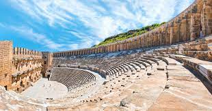
Aspendus Theater is one of the largest ancient buildings of Anatolia and is accepted as one of the best preserved antique theaters known to man. it was built by the local architect Xenon and commissioned in the reign of Marcus Aurelius (2C AD). According to an inscription, it was a gift from the two brothers, Curtius Crispinus and Curtius Auspicatus, who dedicated this monument to the gods of the country and to the imperial house.
The theater’s capacity is estimated to have been 20,000 people. The caveat has a diameter of 95 m / 313 ft and a height of 30 m / 98 ft. The stage building was three stories high. The uppermost facade was used to support an awning-like roof that projected out over the stage, erected more for its acoustical effect than for the shade it provided. The lower levels of the facade were decorated with a double colonnade of ten pairs of columns on each level. A relief of Dionysus and numerous statues, portraits, busts, and reliefs decorated the various levels. in its day it must have been even more grand than it is today.
SIDE
Side was one of the important settlements in the region and today has become one of Turkey’s major holiday centers. The history of the town extends back to the 7th Century BC. Side meant pomegranate in the local language and until the Roman imperial period, the pomegranate was the symbol used on the city coins. in the two centuries following Alexander the Great, Side was generally dominated by the Seleucids of Syria and less often by the Ptolemy of Egypt.
The peak period of the city of Side started around 2C BC once it had established good relations with the Roman Empire. The most impressive of the structures to be seen in town were constructed during those times. Side lost its prominence in the 4th Century AD but it stili continued for some time to prosper as a clerical center. By the lOth Century AD, earthquakes, Christian zealots and Arab raids brought continued decline and the site was abandoned and left to be buried with the passing of time.
The present day entrance to Side is dramatic. One passes through the well-preserved City Walls and through the Main Gate of the ancient city, its colonnaded street. The modern road follows exactly the course of the ancient avenue, although the marble columns that once lined it do not exist anymore. A few broken stubs can be seen near the old Roman baths. The colonnaded street reaches first to the Agora and to the Theater. At the left side of the avenue are the remains of a Byzantine Basilica.
The remains of a public bath have been restored and now serve as the Museum. At the Museum, Roman period statues and sarcophagi are on display. The remains of the Agora can be seen on the left side. This was also the place where the pirates sold their slaves, a lucrative trade in the ancient world.
After the Agora comes the Theater with remains of a Monumental Gate and a Fountain at the entrance. The fountain has been restored. The present remains of the Theater date from the 2C AD. The skein of the theater is in a had state. The theater had a seating capacity of 15000 and was used in the late Roman period for gladiator fights and, by contrast, as an open air church in the 5 and 6th Century AD. Near the theater is the Temple of Dionysus dating from the early Roman period.
ALANYA (CORACESION)
Alanya is the last major resort on the Turkish riviera and reached by a scenic road turning north toward the Taurus Mountains and Konya through banana plantations. Alanya’s pride is its sandy beaches and the great fortress that crowns it. New hotels and apartment blocks line the broad, elegant boulevard which run along the sandy beaches which stretch out on either side of the town. During summer the population nearly doubles and the town turns into a lively colony of predominanüy foreign tourists.
The town did not play an important role in antiquity. At the end of the 2C BC, the notorious pirate ruler
Diodotus Tryphon made it a base for his slaving activities. in 67 BC Pompeii conducted a war against piracy on behalf of Rome along the Mediterranean coast of Anatolia. Mark Anthony presented Coracesion as a wedding gift to Cleopatra. A flight of brick stairs descending the cliffs is said to have been used by Cleopatra to go down for her morn-ing swim. After the Romans and Byzantinians, Cilician kings ruled the city for about 150 years. Later the city was ruled by Seljuk period the town was renamed as Alaiye to honor the conqueror, and shortly after became the winter residence of the Seljuk sultans.
The Fortress is 117 m (384 ft) above the sea with medieval walls running 6 km around the summit. it was originally established as a snial-ler pirate fortress on the protected peninsula but this fortress was con-quered and destroyed by Pompeii in 6th Century BC. Centuries later, Alaattin Keykubat captured the fort after a long siege and made Alanya an important naval base. Today’s fine fortifications were built then. The enormous Dockyards (Tersane) and a Defense Tower, Kizil Kule (Red*-Tower) at the harbor contributed to the town’s role as a naval base.